Apharwat Peak
The highest accessible point in Gulmarg via Asia's largest cable car, offering panoramic Himalayan views near the Line of Control
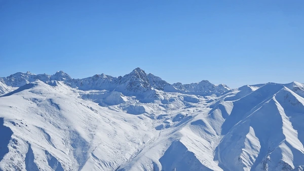
Apharwat Peak is a summit situated at a height of 4,390 metres (14,403 ft) above sea level in Gulmarg, India. Part of the Pir Panjal Range in the Western Himalayas, it receives heavy snowfall and remains covered with snow for much of the year.
The peak holds strategic significance as the Line of Control (LOC) lies barely a few kilometres away. Access to the summit is via the second phase of the Gulmarg Gondola cable car, though reaching this spot is highly dependent on weather conditions.
The Gulmarg Gondola on Apharwat Peak is one of Asia's largest and highest cable cars. Ringed by pine forests and snow-capped Himalayan peaks, it carries skiers and snowboarders to elevations between 3,900 and 4,100 metres on the mountain.
Reaching Apharwat Peak
The Gulmarg Gondola provides the easiest route to the summit
Gulmarg Gondola
- One of Asia's largest and highest cable cars
- Phase 1: Gulmarg to Kongdori (3,080m)
- Phase 2: Kongdori to Apharwat (3,950m)
- Operates weather-permitting; Phase 2 often closed in bad conditions
- Journey time: approximately 20 minutes total
Getting to Gulmarg
Ski & Snowboard Terrain
Over three acres of terrain from beginner slopes to expert runs
Beginner Slopes
7,000 ft (2,134m)
Gentle slopes ideal for first-timers
Phase 1 Runs
10,000 ft (3,048m)
Intermediate terrain with varied runs
Chairlift Access
11,500 ft (3,505m)
Advanced runs via chairlift
Phase 2 Summit
14,000 ft (4,267m)
Expert terrain at the peak
Location & Significance
Strategic position in the Western Himalayas
Geographic Details
- • Location: Gulmarg, Jammu & Kashmir, India
- • Parent Range: Pir Panjal Range (Western Himalayas)
- • Coordinates: 33°59′58″N 74°19′32″E
- • Prominence: 542m (1,778 ft)
- • Easiest Route: Cable car (Gulmarg Gondola)
Key Facts
- • Snow-covered for most of the year
- • Line of Control (LOC) just a few kilometres away
- • Highest ski run in Gulmarg at Phase 2
- • Panoramic views of Himalayan peaks including Nanga Parbat
- • Access dependent on weather conditions
Explore More of Gulmarg
Discover other attractions and winter sports experiences in Gulmarg